


SOUTH G4 GNSS RTK hadir dengan 1698 channel GNSS S805 engine untuk penerimaan sinyal maksimal dan fix lebih cepat di area sulit. Dilengkapi Farlink 2.0 radio 2W, IMU generasi ke-4 calibration-free hingga 60° tilt, serta konektivitas lengkap 4G, WiFi, Bluetooth & NFC. Desain magnesium alloy IP68, baterai tahan lama hingga 20 jam, dan dukungan RTK, Static, PPK & PPP menjadikan G4 solusi andal untuk survey presisi di segala kondisi.
GPS RTK SOUTH G4
Rp165,000,000
Description
GPS RTK SOUTH G4
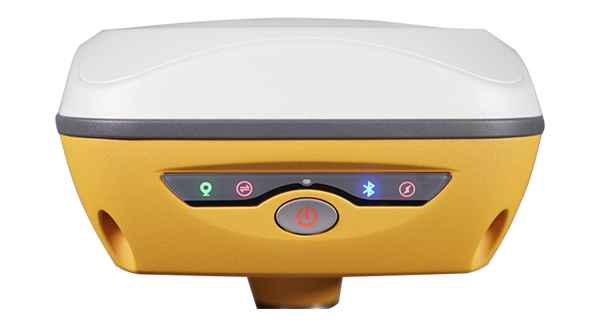
SOUTH G4 GNSS RTK adalah receiver GNSS generasi terbaru yang dirancang khusus untuk surveyor profesional yang membutuhkan kecepatan fix tinggi, stabilitas sinyal maksimal, dan akurasi terbaik di segala kondisi lapangan.
Ditenagai oleh S805 GNSS Engine dengan 1698 channel, SOUTH G4 mampu melacak lebih banyak satelit dan sinyal lemah, bahkan di area ekstrem seperti hutan lebat, kawasan urban padat, dan area dengan gangguan multipath tinggi.
Dilengkapi Farlink 2.0 Radio, IMU Generasi ke-4 (calibration-free), 4G, WiFi, Bluetooth, NFC, serta SSD internal hingga 128GB, G4 adalah solusi all-in-one untuk pekerjaan RTK, Static, PPK, dan PPP tanpa kompromi.
Fitur Unggulan SOUTH G4
- 1698 Channels GNSS – Save Weak Signal
Mesin GNSS S805 dengan kemampuan tracking multi-konstelasi
Fix solution lebih cepat & stabil
Tetap optimal di bawah kanopi pohon dan area bangunan tinggi - Farlink 2.0 Radio – Lebih Stabil & Jangkauan Lebih Jauh
Radio internal 2W UHF (410–470 MHz)
Jangkauan hingga 12 km
Anti interferensi, tetap terkunci pada base yang benar - IMU Generasi Ke-4 – Lebih Produktif
Calibration-free
Tetap aktif meski pole diputar
Sudut tilt hingga 60°
Akurasi tilt < 10 mm + 0.7 mm/° - Material Premium & Tahan Ekstrem
Body Magnesium Alloy AZ91D
Anti benturan, anti karat, pembuangan panas optimal
IP68 waterproof & dustproof
Lolos uji MIL-STD-810G - Modular Lengkap – Siap Segala Kondisi
4G LTE
WiFi hotspot
Bluetooth 5.0
NFC pairing
IMU
SSD internal extendable - SurvStar App & SOUTH Geo Office
CAD draw & stake-out langsung di lapangan
AR stake-out & visual positioning
Static & PPK processing
Dukungan ekspor DXF/DWG & RINEX
Spesifikasi Produk
| Model | G4 |
|---|---|
| GNSS Features | |
| Channels | 1698 |
| GPS | L1, L1C, L2C, L2P, L5 |
| GLONASS | G1,G2,G3 |
| BDS | B1I,B2I,B3L,B1C,B2A,B2B,ACEBOC |
| GALILEO | E1,E5A,E5B,E6 |
| SBAS | L1C,L1A* |
| NavIC/ IRNSS | L5 |
| QZSS | L1,L2C,L5 |
| MSSL - Band | BDS-PPP, GALILEO-HAS |
| Positioning output rate | 1Hz~20Hz |
| Initialization time | < 10s |
| Initialization reliability | >99.99% |
| Positioning Precision | |
| Code differential GNSS | Horizontal: 0.25 m + 1 ppm RMS |
| Vertical: 0.50 m + 1 ppm RMS | |
| Static(long observations) | Horizontal: 2.5 mm + 0.1 ppm RMS |
| Vertical: 3 mm + 0.4 ppm RMS | |
| Static | Horizontal: 2.5 mm + 0.1 ppm RMS |
| Vertical: 3.5 mm + 0.4 ppm RMS | |
| Rapid static | Horizontal: 2.5 mm + 0.5 ppm RMS |
| Vertical: 5 mm + 0.5 ppm RMS | |
| PPK | Horizontal: 3 mm + 1 ppm RMS |
| Vertical: 5 mm + 1 ppm RMS | |
| RTK(UHF) | Horizontal: 8 mm + 1 ppm RMS |
| Vertical: 15 mm + 1 ppm RMS | |
| RTK(NTRIP) | Horizontal: 8 mm + 0.5 ppm RMS |
| Vertical: 15 mm + 0.5 ppm RMS | |
| RTK initialization time | 2 ~ 8s |
| SBAS positioning | Typically < 5m 3DRMS |
| BANDA-L | Horizontal: 5-10cm (5-30min) |
| Vertical: 10-30cm (5-30min) | |
| IMU | Less than 10mm + 0.7 mm/° tilt to 30° |
| IMU tilt angle | 0° ~ 60° |
| Hardware Performance | |
| Dimension | 135mm(W)×135mm(L)×84.75mm(H) |
| Weight | 890g(battery included) |
| Material | Magnesium aluminum alloy shell |
| Operating temperature | -40℃~+65℃ |
| Storage temperature | -35℃~+80℃ |
| Humidity | 100% Non-condensing |
| Waterproof/Dustproof | IP68 |
| Shock/Vibration | MIL-STD-810G(withstand 2meters pole |
| drop onto the cement ground naturally) | |
| Power supply | 6-28V DC, over voltage protection |
| Battery | Inbuilt 7.4V 6800mAh rechargeable |
| Li-ion battery | |
| Battery life | Typically 20h(static), 7h (Base+UHF) |
| 1 9h (Rover+UHF), 20h (Rover+Bluetooth) | |
| 19h (Rover+Cellular Network) | |
| Communications | |
| I/O Port | 5-PIN LEMO external power port + RS232 |
| Type-C(charge+USB+OTG+Ethernet) | |
| 1 UHF antenna interface | |
| Internal UHF | 2W Radio receiver and transmitter |
| Frequency range | 410-470MHz |
| Communication protocol | Farlink, Trimtalk, SOUTH, |
| HUACE,Hi-target,Satel | |
| Communication range | Typically 5km with Farlink protocol, |
| up to 12km | |
| Bluetooth | Bluetooth5.0 standard,Bluetooth2.1+EDR |
| NFC Communication | Realizing close range (shorter than 10cm) |
| automatic pair between receiver and | |
| controller(controller requires NFC | |
| wireless communication module else) | |
| Cellular | 4G |
| WIFI | |
| Modem | 802.11 b/g standard |
| WIFI hot spot | Receiver broadcasts its hot spot form web UI |
| accessing with any mobile terminals | |
| WIFI datalink | Receiver can transmit and receive correction |
| data stream via WiFi datalink | |
| Data Storage/Transmission | |
| Storage | 4GB SSD internal storage standard, |
| extendable up to 128GB | |
| Automatic cycle storage(The earliest data | |
| Files will be removed automatically while the | |
| Memory is not enough) | |
| Support external USB storage | |
| The customizable sample interval is up to 20Hz | |
| Data transmission | Plug and play mode of USB data transmission |
| Supports FTP/HTTP data download | |
| Data format | Static data format:STH,Rinex2.01,Rinex3.02,etc. |
| Differential data format:CMR,RTCM2.1, | |
| RTCM2.3,RTCM3.0,RTCM3.1,RTCM3.2(recommended) | |
| GPS out put data format:NMEA0183,PJK plane | |
| coordinate,Binary code | |
| Network model support:VRS,FKP,MAC, | |
| Fully support NTRIP protocol | |
| Sensors | |
| Electronic bubble | Controller software can display electronic |
| bubble, checking leveling status of the | |
| carbon pole in real-time | |
| IMU | Built-in IMU module, calibration-free |
| and immue to magnetic interference | |
| Thermometer | Built-in thermometer sensor, adopting intelligent |
| temperature control technology, monitoring | |
| and adjusting the receiver temperature | |
| User Interaction | |
| Operating system | Linux |
| Buttons | Single button |
| Indicators | 4LED indicators |
| Web interaction | With the access of the internal web interface |
| management via WiFi or USB connection, users | |
| are able to monitor the receiver status and | |
| change the configurations freely | |
| Voice guidance | It provides status and operation voice guidance, |
| And supports Chinese/English/ | |
| Korean/Spanish/Portuguese/Russian/Turkish | |
| Secondary development | Provides secondary development |
| package, and opens the OpenSIC observation | |
| data format and interaction interface definition | |
| Cloud service | The powerful cloud platform provides online |
| services like remote manage, firmware update, | |
| online register and etc |
Sudah Termasuk dengan :
Base & Rover
Controller
Tripod
Stik Pole Survey
dan pelengkap lainnya
Garansi 1 Tahun
Dapatkan sekarang juga hanya di DND Survey
Harap tanya ketersediaan stok terlebih dulu ya sebelum order:)
Note:
*Membeli = Setuju
*sertakan video unboxing untuk klaim garansi.
*apabila tidak terdapat video unboxing maka klaim garansi tidak berlaku.
*Harga Dapat Berubah Sewaktu-waktu tanpa pemberitahuan terlebih dahulu.
*Mohon tanya ketersediaan barang terlebih dahulu.
*Barang selalu kami cek terlebih dahulu sebelum di kirim.
*Barang di toko kami di jamin original dan baru.
Waktu Pengiriman :
*Senin dan Jumat pukul 11.00 – 15.30 barang langsung dikirim.
*Sabtu pukul 11.00 barang langsung dikirm.
*hari minggu dan libur nasional, dikirim hari berikutnya.
Atau Kunjungi Langsung Office Store Kami :
Alamat : Komplek Sukamenak Indah Block R No.11 Kopo Sayati,Kab Bandung, Jawa Barat 40227.


